
Ride along with me...
#61
 10-28-2019, 07:12 PM


Dear readers...
It occurs to me that some might not understand why some simple things were of great interest to us that might not be to you. Please understand that this narrative was written for the benefit of folks at home as well as anywhere else in the world and, particularly among Janet's notes, there are things which have got more attention than you might think appropriate.
Apart from that...
Have I been near where you live so far on this trip?
Have I reminded you of a trip you've done at some time?
How about making a comment? I would love to hear from you...
#62
10-28-2019, 08:26 PM
Inside the diner there was wall-to-wall… no, not wall-to-wall, the place was absolutely overburdened with motoring, gas station and workshop memorabilia.
There was also a Laurel & Hardy theme. There was so much of it I’ve done it as thumbnails, so just right click on them and click on ‘open in new tab’ for each one.


This might be an appropriate time to mention the other common theme we were finding each morning as we spent time with people over breakfasts in the hotels.
On hearing us speak, they’d ask, "Where are you from?" And when we responded they would always say, "I’d love to go to Australia, you have some of the most interesting animals there!" and similar.
But then they’d ask, "How much of our country have you seen?" Janet would typically answer, "We’ve driven through 23 (or 24, or 25) states." In fact, Washington was the our twenty-seventh state. Anyway, the next response was always, "My, you’ve seen more of America than I have!"
This was to have a significant impact on our lives once we got home. It had crossed both of our minds that, seeing as we would be going back again, next time we’d go through ALL of the states we hadn’t been to this trip.
Still, that kind of planning was some time away. Right now we were on our way to Seattle and we’d crossed most of the agricultural plainlands, now we were about to head into mountain country. It was a 277-mile drive that day and we still had a hundred miles to go. And it still might snow.
There was also a Laurel & Hardy theme. There was so much of it I’ve done it as thumbnails, so just right click on them and click on ‘open in new tab’ for each one.
This might be an appropriate time to mention the other common theme we were finding each morning as we spent time with people over breakfasts in the hotels.
On hearing us speak, they’d ask, "Where are you from?" And when we responded they would always say, "I’d love to go to Australia, you have some of the most interesting animals there!" and similar.
But then they’d ask, "How much of our country have you seen?" Janet would typically answer, "We’ve driven through 23 (or 24, or 25) states." In fact, Washington was the our twenty-seventh state. Anyway, the next response was always, "My, you’ve seen more of America than I have!"
This was to have a significant impact on our lives once we got home. It had crossed both of our minds that, seeing as we would be going back again, next time we’d go through ALL of the states we hadn’t been to this trip.
Still, that kind of planning was some time away. Right now we were on our way to Seattle and we’d crossed most of the agricultural plainlands, now we were about to head into mountain country. It was a 277-mile drive that day and we still had a hundred miles to go. And it still might snow.
Last edited by Ray Bell; 03-23-2020 at 12:43 PM.
#63
10-29-2019, 02:09 AM
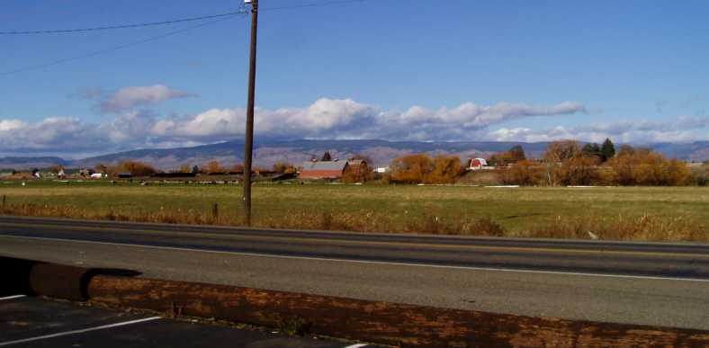
As we left the diner we noted that it was in a nice setting too. Just across the road was a nice farming area, crops, barns and a mountain background with low-hanging clouds�
By this part of the trip I was finding that Janet�s account covers almost everything, taking up pages of her book each day rather than the page or so of the early part. So let�s rely on her account, written as I drove, for the rest of the day�s events as we proceed West from Ellensburg:
She took a bit of a break here as we descended from the mountains towards Seattle...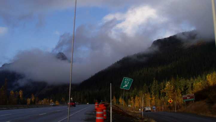
One thing I found interesting was the way Interstate 90 split up during the descent. Westbound traffic clung to the Northern side of a valley, while we could see the Eastbound traffic carving their way up the climb on the Southern side:

The roadbuilders in America don�t let anything get in the way, we�ve seen that time and again during our trip.
The weather eased as we neared Seattle, so it was actually dry and sunny nearer the coast. The scenery was still magnificent�

But all was not smooth sailing as we hit the city environs and the afternoon rush hour:
I had two people to contact in Seattle. The main one was Peter Bakalor, who used to do the Autosport race reports from Australia back in the sixties. I had made some contact with him in recent times, but the phone number I kept ringing got me nowhere now and I was really keen to catch up with him as we prepared to start on the Tasman Cup book.
My phone calls simply weren�t reaching him�
The other person was Eric Haga, Formula 5000 owner and driver. Tony Loxley, the publisher of the F5000 book, was having ideas about doing a book about F5000 in America and so I wanted to talk to Eric. Eric met me in the lobby and we talked for a while, he was enthusiastic and was actually preparing to take his Lola to Australia at that time.
And so she leaves out the fact that, after meeting with Eric, I had to go off and find food for us. Along the way I saw that someone else at the hotel that night had an old Dodge pickup�

�but I sincerely doubt that one was going to travel as far as ours!
So ended Wednesday, November 7, 2012. Thursday would see us heading South. Somewhere along the way (the night in Utah, I think) I�d remembered that one of my goals was to see the California Giant Redwoods, the Giant Sequoias, so I plotted a course which would take us through the area on the California coast where they grow.
By this part of the trip I was finding that Janet�s account covers almost everything, taking up pages of her book each day rather than the page or so of the early part. So let�s rely on her account, written as I drove, for the rest of the day�s events as we proceed West from Ellensburg:
Very pretty countryside, trees look lovely with autumn (fall) tones. Good farm country. We saw our first snow-capped mountain from a distance, though we�re surrounded by rolling hills at the moment, it�s very pretty.
Ray has stopped to take a picture of a truck on the side of the road, advertising something�

��Never seen one like that before,� he said.
Now we�re starting to climb, with views of more snow-capped mountains.

2:35pm. It must be like home, a good area for apples, orchards advertising. That may be what the brightly-coloured crops that we�ve been seeing from a distance have been, the trees with their fall leaves.
Now we�re back in conifer country, conifer forests,�

�with beautiful snow-capped mountains as their backdrop�

Exquisite, it reminds me of what Canada must look like. One mountain has its head in the clouds�

�as very low-lying cloud is coming in. It may even be snow falling ahead of us. There are nice lakes on the side of the road�

�and among the conifer trees there are houses near the road. Climbing, 1,962 feet, summit 3,005 feet. Seventy-seven miles to Seattle, It�s been raining here, everyone�s coming towards us with their lights on. I hope there�s not really bad weather to encounter.
The weather�s unpleasant as we start our climb, raining, not too heavy.
Ray has stopped to take a picture of a truck on the side of the road, advertising something�
��Never seen one like that before,� he said.
Now we�re starting to climb, with views of more snow-capped mountains.
2:35pm. It must be like home, a good area for apples, orchards advertising. That may be what the brightly-coloured crops that we�ve been seeing from a distance have been, the trees with their fall leaves.
Now we�re back in conifer country, conifer forests,�
�with beautiful snow-capped mountains as their backdrop�
Exquisite, it reminds me of what Canada must look like. One mountain has its head in the clouds�
�as very low-lying cloud is coming in. It may even be snow falling ahead of us. There are nice lakes on the side of the road�
�and among the conifer trees there are houses near the road. Climbing, 1,962 feet, summit 3,005 feet. Seventy-seven miles to Seattle, It�s been raining here, everyone�s coming towards us with their lights on. I hope there�s not really bad weather to encounter.
The weather�s unpleasant as we start our climb, raining, not too heavy.
One thing I found interesting was the way Interstate 90 split up during the descent. Westbound traffic clung to the Northern side of a valley, while we could see the Eastbound traffic carving their way up the climb on the Southern side:
The roadbuilders in America don�t let anything get in the way, we�ve seen that time and again during our trip.
The weather eased as we neared Seattle, so it was actually dry and sunny nearer the coast. The scenery was still magnificent�
But all was not smooth sailing as we hit the city environs and the afternoon rush hour:
Ray took a wrong exit, by the time we realised the traffic was disgusting.
Seattle looks beautiful, on Lake Washington. We have found a motel, Hotel Clarion, very nice but a bit more expensive than usual. $69 plus tax. It�s at Renton, south of Seattle.
Ray is meeting up with someone to do with racing, he�s coming to the motel lobby. Ray is also trying to find someone else he hasn�t been able to get in touch with.
My phone calls simply weren�t reaching him�
The other person was Eric Haga, Formula 5000 owner and driver. Tony Loxley, the publisher of the F5000 book, was having ideas about doing a book about F5000 in America and so I wanted to talk to Eric. Eric met me in the lobby and we talked for a while, he was enthusiastic and was actually preparing to take his Lola to Australia at that time.
I had a McDonalds salad for tea and went to bed.
�but I sincerely doubt that one was going to travel as far as ours!
So ended Wednesday, November 7, 2012. Thursday would see us heading South. Somewhere along the way (the night in Utah, I think) I�d remembered that one of my goals was to see the California Giant Redwoods, the Giant Sequoias, so I plotted a course which would take us through the area on the California coast where they grow.
Last edited by Ray Bell; 06-29-2022 at 08:29 AM.
#64
10-29-2019, 04:11 PM
As Thursday, November 8, 2012 dawned we were still over 1,000 miles from Long Beach and Los Angeles. After all, Seattle isn’t far from the Canadian border and LA is getting on towards Mexico. The pickup had now covered over 8,000 miles and had given us no trouble other than two instances of needle and seat problems, the broken throttle spring and the two front wheel bearings.
We were regularly checking the oil and water in the engine and the transmission leak required occasional top-ups of fluid there. Additionally, I had noticed something else which caused me to be circumspect about braking. A small drip of fluid from one of the front flexible brake lines was not going to be easily fixed in these circumstances and I resolved to drive around the problem.
I certainly didn’t tell Janet anything about this or she would undoubtedly have panicked. Of course, while we were on the Interstates there was very little concern, and this was where we had been spending most of our time.
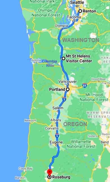
Ultimately we would cover about 350 miles this day to traverse more than half the North/South distance in Washington and get most of the way across Oregon…
So this is how Janet saw our departure from Seattle:
This centre was not far from the Interstate a little further South than than the Toutle River Rest Area and had cameras permanently on the mountain to watch current activity...

It was amazing to learn the full impact of the explosion of this mountain. Railways and highways were washed away by rivers changing their courses, massive areas changed totally in their topography overnight. And after the evacuation during the period the volcano was threatening, a number of people had gone back to their homes and would perish as a result.
Janet continues:
At Woodland the I5 crosses the Lewis River via a pair of steel truss bridges:

Also different was the section where the trains run in between the Southbound and Northbound lanes of the Interstate:

And the everpresent fall colours remind us why we were feeling the chill that day. ..

By the way, the reason the new door seal needed adjusting was because it was from a right side door and I’d fitted it to the left. All drivers’ doors work more than the passengers’ doors, so the seals get more damaged. It took a few days for the seal to settle in to its new shape.
Pierre was an interesting character with a huge background in motor racing. Again, he was a F5000 driver and that was my reason for calling in there. But his history went well beyond F5000 so I was glad to meet him and learn more about his past.
I was still having trouble with my glasses, they were almost threatening to fall off me. My internet efforts to check out on where I had to go to see the Giant Redwoods showed that a stretch of the coast at the very Northern end of California had good stands of these magnificent trees. That quest would dominate our drive on Friday.
And I got a surprise when I returned to the motel, a Chrysler 300C, which shouldn’t have been a surprise...

...but this photo, taken the next morning, shows it has an ‘AWD’ badge. I didn’t know they made these.
We were regularly checking the oil and water in the engine and the transmission leak required occasional top-ups of fluid there. Additionally, I had noticed something else which caused me to be circumspect about braking. A small drip of fluid from one of the front flexible brake lines was not going to be easily fixed in these circumstances and I resolved to drive around the problem.
I certainly didn’t tell Janet anything about this or she would undoubtedly have panicked. Of course, while we were on the Interstates there was very little concern, and this was where we had been spending most of our time.
Ultimately we would cover about 350 miles this day to traverse more than half the North/South distance in Washington and get most of the way across Oregon…
So this is how Janet saw our departure from Seattle:
After our complimentary breakfast we started packing the car, we only brought a couple of bags up this time, not so hard. The car will be hard to start as it is extremely cold. They are predicting blizzards on the West Coast (where we are) so we’re hoping as we travel South it might become milder.
Driving South, out of Seattle’s Southern suburbs it is extremely foggy. A fair bit of traffic, but much more going the other way. It is quite cold, even in the car. We got petrol, it has now turned fine, I had to take a photo of blue sky as it is very uncommon here according to Jerry Entin:

Saw an enormous Boeing shed, they manufacture their aircraft here. So much traffic in the city limits (as they call it), thirty miles from where we stayed last night, which was already about 15 miles South of the city.
Very overcast ahead and there’s a fair bit of police activity, two people being pulled up by motorcycle police. It’s now 9:25am, still a fair bit of traffic both ways.

Now we drive past what looks like a lot of trains waiting to die, graffiti on them, sitting there, rusting, going for miles:

We went past an outlet place, Ray asked if I wanted to stop. But bad weather seems to be rolling in, I’d like to get through it as soon as possible so we didn’t stop. A menacing sky and the forecast of blizzard conditions are worrying.
There’s a strong smoke smell after Toledo with a haze, could be adding to that menacing-looking sky. We’re starting to climb and stop at a rest area for coffee. People here just love their dogs, once again quite a few dogs being walked by adoring owners.
Volunteers were making coffee for travellers but we had our own. Very chilly here, I’m glad I have a warm coat and hat. Ray had put a door trim rubber he got in Spokane yesterday for his door to stop the draft we’ve put up with the whole trip. He had to readjust that now and put a different rear vision mirror on as well, try to adjust my sunvisor that has been flopping down all trip, it is absolutely freezing here!
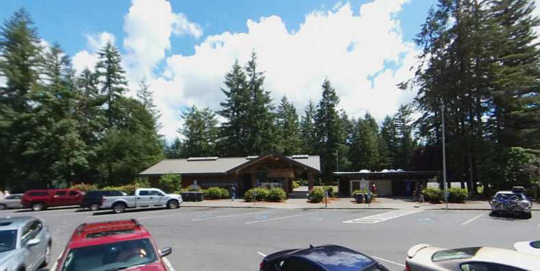
We went to the Mount St Helens Visitor Center. It was quite interesting, we paid to see their 13-minute film about the eruption on May 18, 1980.
Driving South, out of Seattle’s Southern suburbs it is extremely foggy. A fair bit of traffic, but much more going the other way. It is quite cold, even in the car. We got petrol, it has now turned fine, I had to take a photo of blue sky as it is very uncommon here according to Jerry Entin:
Saw an enormous Boeing shed, they manufacture their aircraft here. So much traffic in the city limits (as they call it), thirty miles from where we stayed last night, which was already about 15 miles South of the city.
Very overcast ahead and there’s a fair bit of police activity, two people being pulled up by motorcycle police. It’s now 9:25am, still a fair bit of traffic both ways.
Now we drive past what looks like a lot of trains waiting to die, graffiti on them, sitting there, rusting, going for miles:
We went past an outlet place, Ray asked if I wanted to stop. But bad weather seems to be rolling in, I’d like to get through it as soon as possible so we didn’t stop. A menacing sky and the forecast of blizzard conditions are worrying.
There’s a strong smoke smell after Toledo with a haze, could be adding to that menacing-looking sky. We’re starting to climb and stop at a rest area for coffee. People here just love their dogs, once again quite a few dogs being walked by adoring owners.
Volunteers were making coffee for travellers but we had our own. Very chilly here, I’m glad I have a warm coat and hat. Ray had put a door trim rubber he got in Spokane yesterday for his door to stop the draft we’ve put up with the whole trip. He had to readjust that now and put a different rear vision mirror on as well, try to adjust my sunvisor that has been flopping down all trip, it is absolutely freezing here!
We went to the Mount St Helens Visitor Center. It was quite interesting, we paid to see their 13-minute film about the eruption on May 18, 1980.
It was amazing to learn the full impact of the explosion of this mountain. Railways and highways were washed away by rivers changing their courses, massive areas changed totally in their topography overnight. And after the evacuation during the period the volcano was threatening, a number of people had gone back to their homes and would perish as a result.
Janet continues:
What led up to it – many earthquakes etc – were explained in this great exhibit. It highlights the importance of taking heed of and acting in advance warnings. One old man named Truman, when warned, said, “I’m not going anywhere, I’m a part of the mountain and it’s a part of me.”
Another man was asked to watch activity from a vantage point seven miles away. Both of them died. But many heeded the warnings and were saved.
The weather now seems to be clearing a bit, we can see more blue sky. Now we’re driving alongside the Columbia River…

...before we get into Oregon. The train track is between us and the river.

Another man was asked to watch activity from a vantage point seven miles away. Both of them died. But many heeded the warnings and were saved.
The weather now seems to be clearing a bit, we can see more blue sky. Now we’re driving alongside the Columbia River…
...before we get into Oregon. The train track is between us and the river.
Also different was the section where the trains run in between the Southbound and Northbound lanes of the Interstate:
And the everpresent fall colours remind us why we were feeling the chill that day. ..
By the way, the reason the new door seal needed adjusting was because it was from a right side door and I’d fitted it to the left. All drivers’ doors work more than the passengers’ doors, so the seals get more damaged. It took a few days for the seal to settle in to its new shape.
We go across a long bridge into Oregon...

Nine miles until we arrive at the home of another fellow Ray wants to see. Portland traffic is heavy:

We drive to his address, quite a nice area – semi rural – I was invited in and watched TV while Ray spoke with Pierre Phillips for over an hour. We had a nice coffee, the nicest I’d had in America.
On our way now to Williams, California. 500 miles to go, we won’t get there today. Ray needs to pick up some things from there.
Nine miles until we arrive at the home of another fellow Ray wants to see. Portland traffic is heavy:
We drive to his address, quite a nice area – semi rural – I was invited in and watched TV while Ray spoke with Pierre Phillips for over an hour. We had a nice coffee, the nicest I’d had in America.
On our way now to Williams, California. 500 miles to go, we won’t get there today. Ray needs to pick up some things from there.
Travelling South from Portland – fairly heavy traffic. We’re not on the main road yet out of the city, it’s 3pm, it must be the start of peak time. We also found out that in Oregon you can’t pump your own gas. They also wash your windscreen.
The trees, once again, are lovely with their autumn leaves. Quite a bit of traffic both ways. Green country, we got a few sprinkles of rain. There are pretty crop colours, copper, red, they seem to be growing trees, they’re only tiny so far.
Lovely farmland – mountains at a distance…

...sheep grazing, not a common sight. Very lush country, we had to do a lot of climbing before we reached our destination for the night. This was the Travelodge at Roseburg, it is now 6:45pm.
Ray went out to get a couple of frozen meals for tea, get money out and bought a few other things while I stayed in the motel. Very cold.
The trees, once again, are lovely with their autumn leaves. Quite a bit of traffic both ways. Green country, we got a few sprinkles of rain. There are pretty crop colours, copper, red, they seem to be growing trees, they’re only tiny so far.
Lovely farmland – mountains at a distance…
...sheep grazing, not a common sight. Very lush country, we had to do a lot of climbing before we reached our destination for the night. This was the Travelodge at Roseburg, it is now 6:45pm.
Ray went out to get a couple of frozen meals for tea, get money out and bought a few other things while I stayed in the motel. Very cold.
And I got a surprise when I returned to the motel, a Chrysler 300C, which shouldn’t have been a surprise...
...but this photo, taken the next morning, shows it has an ‘AWD’ badge. I didn’t know they made these.
Last edited by Ray Bell; 07-03-2022 at 11:15 PM.
#65
10-29-2019, 06:37 PM
November 9, 2012…
It was now Friday on the final full week of our journey. My glasses were proving a problem as the nose pads come apart and the whole of the bridge section is loose due to the plastic inserts in the lenses having worn out and fallen apart. Nobody seems to have these inserts or anything to substiture.
We awoke to yet another cool morning, packed our gear into the truck and started to drive, the Garmin set to take us to the coast and the Giant Sequoias. I have always wanted to see these majestic trees, remembering photos of them with cars driving through tunnels cut in them from my school days.
Janet narrates as we continue south on Interstate 5:
That’s right, I didn’t keep Janet abreast of things which I felt would concern her unduly. She would have really freaked if she’d known about the leak I’d spotted in the brake hose. I was, however, taking no chances with running out of fuel. And I’d always refuel if I felt we were going into an area where prices would be higher.
It was hard to tell from the map how much extra mileage there would be, but I think it was more than 100 miles. The road from Grant’s Pass crosses a coastal mountain range before descending to Crescent City.
Here’s the map of Friday’s drive:

The ‘arty’ side of people here had conspired to display a police car from the early-fifties...

...and to decorate their toilet block with a huge fly!

The ‘Oregon Cop Car’ shows up readily on Google Earth, but the fly is harder to find. It’s there tucked away a short distance behind an old railcar next to a gas station, which seems to be tied to the O’Brien ‘Country Store’.

And that’s us! Slower traffic as we climb towards the border.
We certainly were hungry when we got to Crescent City. We did go to the visitor’s centre first, seen on the left in the pic above, then turned back to get to the various food vendors. It’s a very open town, lots of space and parking areas, quite inviting.
As we headed South from Crescent City, we didn’t know just how big an afternoon we had ahead of us, but we were beginning to see how big the trees might become.
It was time now to see them in all their magnificence...
It was now Friday on the final full week of our journey. My glasses were proving a problem as the nose pads come apart and the whole of the bridge section is loose due to the plastic inserts in the lenses having worn out and fallen apart. Nobody seems to have these inserts or anything to substiture.
We awoke to yet another cool morning, packed our gear into the truck and started to drive, the Garmin set to take us to the coast and the Giant Sequoias. I have always wanted to see these majestic trees, remembering photos of them with cars driving through tunnels cut in them from my school days.
Janet narrates as we continue south on Interstate 5:
I noticed a number of signs for wineries late yesterday and again today. It must be good grape-growing country. Climbing already, there's snow predicted today in Oregon, further inland from where we are, I think.
I just found out we have no fuel gauge, so we have to remember when we got petrol and how many miles we've covered. We lost the fuel gauge in Spokane.
I just found out we have no fuel gauge, so we have to remember when we got petrol and how many miles we've covered. We lost the fuel gauge in Spokane.
It is a big logging area around here, that was attested by a train carrying processed timber. More sheep, I just had to take a picture…

…some had long tails, I’ve never seen that before. But it didn’t show in the photo either!
South Umpqua, we got petrol about 20 miles from Roseburg. As we climb the low cloud and the beautiful fall trees are great…


We have stopped at Grants Pass in Oregon at an Optometrist for Ray to get the nose pad put back on his glasses for the third time. First when we were at Jerry’s in Spring Lake, second in Spokane and now, hopefully, it will be done more permanently.
The first time and second time were free, this time they charged $3. Went to a Dollar Tree shop, Ray wanted to get some cheap glasses in case his break. Two pairs for $2. I bought deoderant, $1, didn’t have any normal tea.
Grants Pass is a pretty little place, lovely autumn trees line streets. We found a thrift shop and bought a couple of things, including a glass case for Ray, now on our way to see the Redwood trees, we had to turn off the main road, we will probably be doing an extra 100 miles to see trees.
…some had long tails, I’ve never seen that before. But it didn’t show in the photo either!
South Umpqua, we got petrol about 20 miles from Roseburg. As we climb the low cloud and the beautiful fall trees are great…
We have stopped at Grants Pass in Oregon at an Optometrist for Ray to get the nose pad put back on his glasses for the third time. First when we were at Jerry’s in Spring Lake, second in Spokane and now, hopefully, it will be done more permanently.
The first time and second time were free, this time they charged $3. Went to a Dollar Tree shop, Ray wanted to get some cheap glasses in case his break. Two pairs for $2. I bought deoderant, $1, didn’t have any normal tea.
Grants Pass is a pretty little place, lovely autumn trees line streets. We found a thrift shop and bought a couple of things, including a glass case for Ray, now on our way to see the Redwood trees, we had to turn off the main road, we will probably be doing an extra 100 miles to see trees.
Here’s the map of Friday’s drive:
Climbing again. Quaint little villages, antique and collectables stores, arty people...


Then we get to bigger towns, Illinois Valley. We went past a flea market and quite a few thrift shops. A big lumber mill.
There is snow not too far away and not that high. Low cloud ahead, we stopped for a coffee at a little place called O’Brien and it was raining...
Then we get to bigger towns, Illinois Valley. We went past a flea market and quite a few thrift shops. A big lumber mill.
There is snow not too far away and not that high. Low cloud ahead, we stopped for a coffee at a little place called O’Brien and it was raining...
...and to decorate their toilet block with a huge fly!
The ‘Oregon Cop Car’ shows up readily on Google Earth, but the fly is harder to find. It’s there tucked away a short distance behind an old railcar next to a gas station, which seems to be tied to the O’Brien ‘Country Store’.
And that’s us! Slower traffic as we climb towards the border.
We just crossed into California. For the first time we had to stop for a plant and produce check. We had no fruit or anything.
It is snowing where we stopped for restrooms (toilets) – Colliers Tunnel Rest Area – we just went through a short tunnel, took photos...


Winding road, going downhill, tall conifers, no snow down here. Narrow winding road continues, rock slide area, all a bit scary. A small airport at bottom of the mountains together with a small plane, it would need a skilled pilot – surrounded by mountains.
It’s now raining heavier, the Smith River rapids flowing beside us, the sun’s trying to come out, the trees are getting taller, so close to the road.
Incredible, we stopped to take photos – very mossy on trees and they seem to be intertwined with each other…


The road opens up and we’re now on a freeway. We arrive at Crescent City and go into the information centre…
We got petrol, no more getting petrol put in for you now we’re in California.
Had a wrap from McDonalds for lunch, cheap and tasty.
It is snowing where we stopped for restrooms (toilets) – Colliers Tunnel Rest Area – we just went through a short tunnel, took photos...
Winding road, going downhill, tall conifers, no snow down here. Narrow winding road continues, rock slide area, all a bit scary. A small airport at bottom of the mountains together with a small plane, it would need a skilled pilot – surrounded by mountains.
It’s now raining heavier, the Smith River rapids flowing beside us, the sun’s trying to come out, the trees are getting taller, so close to the road.
Incredible, we stopped to take photos – very mossy on trees and they seem to be intertwined with each other…
The road opens up and we’re now on a freeway. We arrive at Crescent City and go into the information centre…
We got petrol, no more getting petrol put in for you now we’re in California.
Had a wrap from McDonalds for lunch, cheap and tasty.
As we headed South from Crescent City, we didn’t know just how big an afternoon we had ahead of us, but we were beginning to see how big the trees might become.
It was time now to see them in all their magnificence...
Last edited by Ray Bell; 07-09-2022 at 05:28 AM.
#66
10-30-2019, 05:33 AM
After lunch at Crescent City we still had about 200 miles to go to Redding, which was back up on the I5 and the gateway to our remaining destinations. We had done about 145 miles since Roseburg, now we were entering the area where stopping to enjoy the sights was the main concern.
So, our stomachs satisfied, we continued…
This drive was just fabulous, it also underlined the fact that we had driven from one coast to the other in the USA, though it was now about five weeks since we’d saw the Atlantic from Long Island.
There were many small outcrops just off the coast, like little islands...

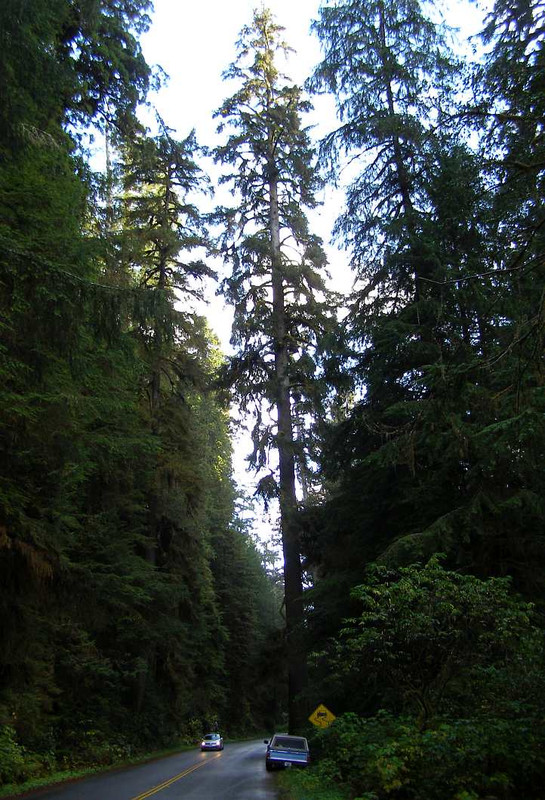
...and we were both enjoying the sunshine of the afternoon and the very special sight that these trees were. Though they were tall, not many had the kind of girth necessary for a tunnel to be carved through them as I’d seen so many photos of when I was young. But this mattered not...
And there was evidence that winds can damage these forests:

Of course, the tourist potential of the Giant Redwoods has not been lost. This private stand of trees draws crowds...

...and a look at their website shows that they’ve gone to some effort to make it all very attractive to visitors.
https://www.treesofmystery.net/
But it was not for us, as we had to keep moving as the day drew on. Janet continued...

I have to agree that it hurts your neck as I was looking for photo opportunities. The Sequoias have bare-looking trunks for a lot of their height, then branches and greenery grow in abundance way up there in the sunshine...

And there’s certainly no shortage of them. Periodically we’d stop in an effort to get better photos, but it was so hard because of the closeness of the trees to both the road and each other.

The afternoon was closing in, or so it seemed as we were buried in the midst of the sun-blocking foliage. Sometimes the sun would shine through...

...but there was still a darkness about the drive due to the sheer size of shadow thrown by trees approaching 120 metres tall. The road continued in this gloom for some distance...

...and finally we came out of it. But it was with some sadness to me that we put those monoliths behind us. And remembered that even they don’t live forever.

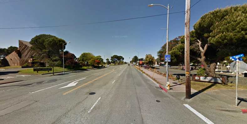
We neared McKinleyville where we would turn to head for Redding.
Confession time. As we left the service station I turned to the East, there were no cars anywhere, I instinctively went to the left side of the road. Six weeks into this drive and I made this mistake, quickly correcting it when a car came over the crest towards us in the distance. I think Janet was a little shaken by that, possibly more so because she saw it as her job to remind me when I erred.
Yes, it was slow. In part it was so slow because both ascents and descents were taken in low gear – the ascents because of the steepness, the load and the lack of power; the descents to avoid having to put pressure on those brakes. Throughout it all we were reading the altitude from the Garmin.
2,000ft – rain. 3,000ft – snow! 4,000ft – prepare for slow descent. Three times, though the third pass didn’t have any snow.
Even so, the slant 6 was still willing and doing a fine job. At Weaverville, a town about 45 miles short of our destination, we stopped for food. And, in time, the Interstate came into sight and we were looking for a motel in Redding.
Our room was a strange one, tucked into a corner of the building and oddly-shaped. But it was a warm room with a bed and a shower, it was all we needed that night.
So, our stomachs satisfied, we continued…
Saw the ocean and took a photo of it...

...now we’re climbing, giant trees tower over us, they look like conifers. We’re instructed by a sign to have headlights on day and night. There’s mist still hanging in the trees even though the sun’s out and it’s 2:10pm.
It’s hard to think when you’re driving through an avenue of tall – very tall – trees…

...that we’re right on the coastline. It wasn’t until we had to stop for some roadworks that I remembered, we could see the Pacific Ocean. We stopped to take some lovely photos of the coast.

...now we’re climbing, giant trees tower over us, they look like conifers. We’re instructed by a sign to have headlights on day and night. There’s mist still hanging in the trees even though the sun’s out and it’s 2:10pm.
It’s hard to think when you’re driving through an avenue of tall – very tall – trees…
...that we’re right on the coastline. It wasn’t until we had to stop for some roadworks that I remembered, we could see the Pacific Ocean. We stopped to take some lovely photos of the coast.
There were many small outcrops just off the coast, like little islands...
...and we were both enjoying the sunshine of the afternoon and the very special sight that these trees were. Though they were tall, not many had the kind of girth necessary for a tunnel to be carved through them as I’d seen so many photos of when I was young. But this mattered not...
And there was evidence that winds can damage these forests:
Of course, the tourist potential of the Giant Redwoods has not been lost. This private stand of trees draws crowds...
...and a look at their website shows that they’ve gone to some effort to make it all very attractive to visitors.
https://www.treesofmystery.net/
But it was not for us, as we had to keep moving as the day drew on. Janet continued...
We drove further along and I took photos of Ray driving through a Redwood tree at Klamath...

They had emus here, an unusual sight!
We’ve also driven into Prairie Creek Redwoods State Park. The trees are truly majestic, it hurts your neck craning to see the tops of some. Most of them are not so big in diameter.
They had emus here, an unusual sight!
We’ve also driven into Prairie Creek Redwoods State Park. The trees are truly majestic, it hurts your neck craning to see the tops of some. Most of them are not so big in diameter.
I have to agree that it hurts your neck as I was looking for photo opportunities. The Sequoias have bare-looking trunks for a lot of their height, then branches and greenery grow in abundance way up there in the sunshine...
And there’s certainly no shortage of them. Periodically we’d stop in an effort to get better photos, but it was so hard because of the closeness of the trees to both the road and each other.
The afternoon was closing in, or so it seemed as we were buried in the midst of the sun-blocking foliage. Sometimes the sun would shine through...
...but there was still a darkness about the drive due to the sheer size of shadow thrown by trees approaching 120 metres tall. The road continued in this gloom for some distance...
...and finally we came out of it. But it was with some sadness to me that we put those monoliths behind us. And remembered that even they don’t live forever.
We neared McKinleyville where we would turn to head for Redding.
4:15pm – the sun is shining and the sky is nothing but blue. We are now driving South along the coast with conifers on both sides of the road. It is a good road now, before it was narrow and winding.
Before Eureka, on the coastal road, we had to turn East to go inland. On the bridge approach going over the coastal road there were gum trees, the first time we’ve seen them in the USA.
It’s now coming over cloudy, low cloud. It’s 4:45pm, going towards Redding, 134 miles to go. Apparently there are three mountain passes to go through before our destination. Stopped at Blue Lake (132 miles to go) to get petrol.
Climbing, mist rolling in, looks like it’s rained here. All in all, not very pleasant to be driving as it’s getting dark. Now it’s raining, mixed with snow on the summit.
The trip to Redding just got worse, it went on forever, we never stopped climbing and then descending along the windiest road imaginable. One climb was so steep we were nearly stopped. To make matters worse it was all in the dark.
The trip to Redding just got worse, it went on forever, we never stopped climbing and then descending along the windiest road imaginable. One climb was so steep we were nearly stopped. To make matters worse it was all in the dark.
2,000ft – rain. 3,000ft – snow! 4,000ft – prepare for slow descent. Three times, though the third pass didn’t have any snow.
Even so, the slant 6 was still willing and doing a fine job. At Weaverville, a town about 45 miles short of our destination, we stopped for food. And, in time, the Interstate came into sight and we were looking for a motel in Redding.
Arrived at Redding at 9pm after having tea at Burger King (never again!) at Weaverville.
Last edited by Ray Bell; 10-30-2019 at 05:54 AM.
#67
10-30-2019, 03:59 PM
Saturday, and we left Redding. It was before 9:00am when Janet started to write in her diary. “What’s the date today?” she asked.
“Well, the twelfth is the date we fly out and that’s on Tuesday, so it must be the ninth.” I answered. But by this time she’d flicked back to the Friday notes and seen that it was the ninth on the Friday. This caused me to check my mobile phone and… sure enough, the date was the tenth. We were to fly out on Monday!
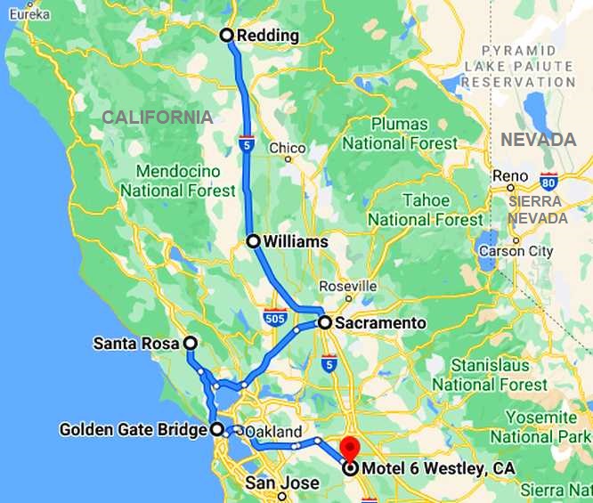
While a discussion ensued about having to cram a lot of distance into Saturday and Sunday, we had to work out the details during the day. I would have three people I needed to call on and we’d want to be well past San Francisco before we stopped. In the end, this was our driving day:
It would amount to over 400 miles with the running around we had to do. As we pressed on down the I5. Janet wrote:
Not only petrol in Corning, we saw a sign for a garage sale and had a look...

...but I don’t think we spent any money.
Looking at that last pic now I realise that the trees are eucalypts. I’m not sure whether or not we noticed that at the time, maybe it just seemed natural to us?
As we drove into this rest area a strange vehicle caught my attention:

Naturally I thought, "What is it? Or what was it originally?" Apart from the fact that it’s left hand drive, I might have thought it was an old postal delivery van. It has some seriously heavy-duty underpinnings with those 8-stud wheels but it’s so short. And is there a lot of wisdom in having all that overhang with such a short wheelbase?
After our coffee stop we drove on. John Fowlie was the man at Williams where he has a wrecking yard called ‘Big M’, that was our next destination...
Big M is a long-established business. I bought some stuff from John several years ago and he accidentally sent the wrong parts. This day I was there to get something else to make up for that. Eventually we slipped three old Chrysler rear axle housings into the back of the pickup.
In the meantime I looked around his ‘stock’...

...these older cars were almost out of place, but John is looking to sell them to restorers. Just as he is some of the Forward Look era (1956-61) Chrysler derivatives...

And while he has a liking for the Chrysler stuff, a personal preference you might say, the mainstay of the business is wrecking Mercury (hence the ‘Big M’) models and then there’s the odd Edsel:

All in all, though, it just looks like any other old-style wrecking yard...

...and it made me feel right at home. John was good to meet and deal with, his wife wasn’t well that day and didn’t spend any time with us. And we had to keep moving too. There was about sixty miles to go to Sacramento where I was to catch up with another Mopar forum member, John Kunkel, then it would be 95 miles to Santa Rosa to see Rex Ramsay, who had been one of the F5000 drivers who travelled to New Zealand’s Bay Park in 1969 to show off the cars with a view to F5000 becoming the formula for the Tasman Cup races in the future.
A full day...

Crossing the Sacramento River just after Woodland at Fremont we entered Sacramento County. We skirted around the city to get to John’s place...
John invited us both in and we had a good chat. I’d been keen to meet him because he has so much knowledge about the cars he fancies and generally has answers to people’s technical questions, I wanted to find out where he got all this knowledge.
When we left, Janet expressed her pleasure at how well he had received and treated us both.
The Garmin took us off the Interstate eventually and through some secondary roads, but it was getting dark. Janet had tried to get a good shot of the sunset as we travelled along:

This would be the last photo for the day and we knew we had to be on the road well into the evening.
Rex was delighted to see me and get a copy of the F5000 book (in which he’d written a chapter), he tried to make me feel welcome but I realised that there was no time to waste and it wasn’t long before we left there, and Santa Rosa, with about 55 miles between us and San Francisco.
We were now looking for somewhere to spend the night, we had unfortunately crossed the Golden Gate and the San Francisco-Oakland Bay bridges in the dark. But getting clear of San Francisco was important to make the Sunday an easier run to Los Angeles, I wanted the Monday free in LA so I could get a new windscreen fitted to the pickup, prepare for the flight home and put the pickup in at the shipping company for its slower ride across the Pacific.
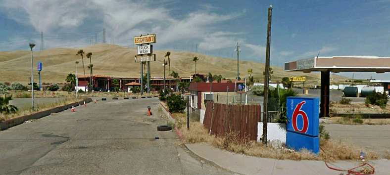
Westley presented itself, about forty miles South, with a Motel 6 right on the Freeway, though Janet had reservations about how she would sleep with a Truck Stop right next door...
We were now about 70 miles into the drive from San Francisco to Los Angeles. Our pact at the start of the trip not to travel at night was blown to ribbons this evening, it was well after 10pm when we checked in, even later than we’d checked in at Buckhannon, West Virginia, Niagara Falls or Dillon, Montana.
It was a real shame to have missed out on seeing a bit of San Francisco, its famous waterways and bridges, in the daylight but at least we did traverse those bridges. And we had an important date with a Virgin flight from LA on Monday evening.
“Well, the twelfth is the date we fly out and that’s on Tuesday, so it must be the ninth.” I answered. But by this time she’d flicked back to the Friday notes and seen that it was the ninth on the Friday. This caused me to check my mobile phone and… sure enough, the date was the tenth. We were to fly out on Monday!
While a discussion ensued about having to cram a lot of distance into Saturday and Sunday, we had to work out the details during the day. I would have three people I needed to call on and we’d want to be well past San Francisco before we stopped. In the end, this was our driving day:
It would amount to over 400 miles with the running around we had to do. As we pressed on down the I5. Janet wrote:
We are driving towards Sacramento. Ray has to meet up with someone in a little place, Williams, before Sacramento. 8:50am, 107 miles until we get there.
A lot of smoke billowing from stacks of a tyre factory in Anderson and a lot of outlet stores – one said ‘Christian Outlet’ - hate to think what might be in there.
We can see snow-capped mountains in the direction we came over last night. What an experience that was, one I wouldn’t like to repeat.
There’s one wind turbine sitting out in a field, it’s not turning and looks lonely. Orchards on both sides of the highway, one offering prunes so they must grow plums. There’s a sign on the back of a van - ‘Rattler on Board’ - a good deterrent! Lots more orchards on both sides. Thousands of what look to be young fruit trees.
Stopping at ‘Corning, the Olive City’ for petrol, there are lots of olive trees around.
...but I don’t think we spent any money.
Lots of olive trees around. Now the trees have finished making way for fields, cows grazing, a few beehives and signs of some sort of mining right next to the highway.
More olives and a rundown orchard, then back to the well-manicured orchards on both sides of the highway. We stopped at a rest area for coffee, two border collies were there with their owner, playing frisbies. They love their dogs.
Hard-working farmers around by the look, tilled soil, olive trees, orchards, I saw a sign which said,
"Farmers Feed Americans."
As we drove into this rest area a strange vehicle caught my attention:
Naturally I thought, "What is it? Or what was it originally?" Apart from the fact that it’s left hand drive, I might have thought it was an old postal delivery van. It has some seriously heavy-duty underpinnings with those 8-stud wheels but it’s so short. And is there a lot of wisdom in having all that overhang with such a short wheelbase?
After our coffee stop we drove on. John Fowlie was the man at Williams where he has a wrecking yard called ‘Big M’, that was our next destination...
A few marshy paddocks, maybe growing rice? Covered haystacks, they’re covered with a tarpaulin arrangement held down with hundreds of tyres all over – ingenious. Big silos, so many of them...


...and a train track running alongside the Interstate.

It must have been rice we saw growing, one of the silos had ‘Rice’ written on it. There were acres upon acres of fruit trees before we turned off at Arbuckle. Ray can’t find the address of the fellow he wants to see, the GPS has done it again, sent us on another wild goose chase.
We are miles from Williams, where he’s supposed to live. Ray went into a shop to ask someone, he just so happens to have sold him a car so he gave us directions – five or six miles back.
We went past ADM Rice silo going down a service road alongside the Interstate back towards Williams. Population 5,225. I was just informed we’re not going to John’s home but to his wrecking yard, though he does live there. We arrived and I sat in the car.
We’ve now done 9,000 miles on this trip.
Ray asked me to come and have a look at what he had in his yard – oh, goody! I did for a while but I could only take so much and I’m back sitting in the car. John’s wife must like old cars, she has a couple of cars locked up in a shed as well as another car she must drive which has rubber eyelashes above the headlights. I saw those for the first time yesterday at Grants Pass, thought it was a novel idea then.
...and a train track running alongside the Interstate.
It must have been rice we saw growing, one of the silos had ‘Rice’ written on it. There were acres upon acres of fruit trees before we turned off at Arbuckle. Ray can’t find the address of the fellow he wants to see, the GPS has done it again, sent us on another wild goose chase.
We are miles from Williams, where he’s supposed to live. Ray went into a shop to ask someone, he just so happens to have sold him a car so he gave us directions – five or six miles back.
We went past ADM Rice silo going down a service road alongside the Interstate back towards Williams. Population 5,225. I was just informed we’re not going to John’s home but to his wrecking yard, though he does live there. We arrived and I sat in the car.
We’ve now done 9,000 miles on this trip.
Ray asked me to come and have a look at what he had in his yard – oh, goody! I did for a while but I could only take so much and I’m back sitting in the car. John’s wife must like old cars, she has a couple of cars locked up in a shed as well as another car she must drive which has rubber eyelashes above the headlights. I saw those for the first time yesterday at Grants Pass, thought it was a novel idea then.
In the meantime I looked around his ‘stock’...
...these older cars were almost out of place, but John is looking to sell them to restorers. Just as he is some of the Forward Look era (1956-61) Chrysler derivatives...
And while he has a liking for the Chrysler stuff, a personal preference you might say, the mainstay of the business is wrecking Mercury (hence the ‘Big M’) models and then there’s the odd Edsel:
All in all, though, it just looks like any other old-style wrecking yard...
...and it made me feel right at home. John was good to meet and deal with, his wife wasn’t well that day and didn’t spend any time with us. And we had to keep moving too. There was about sixty miles to go to Sacramento where I was to catch up with another Mopar forum member, John Kunkel, then it would be 95 miles to Santa Rosa to see Rex Ramsay, who had been one of the F5000 drivers who travelled to New Zealand’s Bay Park in 1969 to show off the cars with a view to F5000 becoming the formula for the Tasman Cup races in the future.
A full day...
Two hours later and we’re on our way, it’s 2pm and it’s a beautiful day. The sun is shining, it’s not cold and not hot, just nice.
Going past even more orchards, it’s now 41 miles to Sacramento. A few more sheep (without tails) then some gum trees just there beside Interstate 5 in California. And orchards galore.
We stopped at Denny’s at Woodland, about 15 miles North of Sacramento. Ray has to see someone in Sacramento, we’re going there now. Ray thought he had an extra day, Tuesday instead of Monday, here in the USA, so things are going to be a bit more rushed than he anticipated.
Crossing the Sacramento River just after Woodland at Fremont we entered Sacramento County. We skirted around the city to get to John’s place...
Such a big housing estate as you go off the Interstate, no land, all house, a fenced community it looked like. Ray has just stopped to take a photo of some sheep, one had a tail, I hope he finds it...

...who would think seeing sheep would be enough to stop and take a photo?
We saw someone selling produce, pomegranates, mandarins etc out of the back of their vehicle on the side of the road, first time I’ve seen that in the USA. On the road again, Ray said he got a photo of the sheep with a tail.
We arrived at John’s place...
When we left, Janet expressed her pleasure at how well he had received and treated us both.
At 4:30pm we left John’s, on the way to another fellow’s place at Santa Rosa, 91 miles away. There’s quite a bit of traffic, going both ways, for a Saturday...


...more traffic staying with us.
...more traffic staying with us.
This would be the last photo for the day and we knew we had to be on the road well into the evening.
What I could see in the dark – nice little communities, specialty shops – reminds me of Montville. Another area had vendors selling their wares – mainly food out of caravans on the side of the road.
Ray spent about 30 minutes with Rex from Santa Rosa. We made our way to San Francisco to go over the Golden Gate Bridge. Did that, paid $6 toll and then proceeded to get lost in the city. We went through a few tunnels, saw a trolley bus and tram and steep roads and a lot of lights.
We ended up crossing the river again on another longer bridge, not very attractive. We finally found our way out of San Francisco, made our way towards San Jose.
Trains from San Francisco to San Jose run in the middle of the Interstate. We joined up with Interstate 5 California on the way to Los Angeles.
Westley presented itself, about forty miles South, with a Motel 6 right on the Freeway, though Janet had reservations about how she would sleep with a Truck Stop right next door...
We were now about 70 miles into the drive from San Francisco to Los Angeles. Our pact at the start of the trip not to travel at night was blown to ribbons this evening, it was well after 10pm when we checked in, even later than we’d checked in at Buckhannon, West Virginia, Niagara Falls or Dillon, Montana.
It was a real shame to have missed out on seeing a bit of San Francisco, its famous waterways and bridges, in the daylight but at least we did traverse those bridges. And we had an important date with a Virgin flight from LA on Monday evening.
Last edited by Ray Bell; 02-03-2021 at 07:20 AM.
#68
10-30-2019, 06:19 PM
Looking back at that strange camper we saw at the rest area, I'm wondering if anyone can give any clues to what it might have been?
Here's a closer look from a different angle, unfortunately partly blocked by the tree...
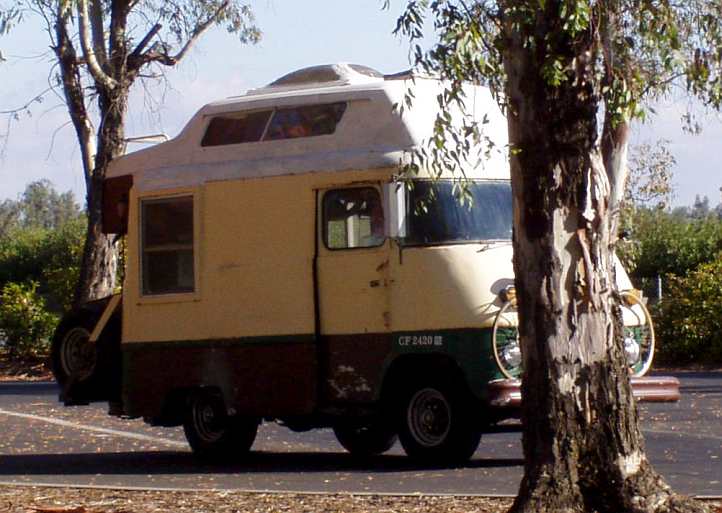
...It seems to me that it's a very short wheelbase, while it does have the 8-lug wheels to indicate significant weight carrying capacity. It's not 4WD, there's a beam axle under the front but no differential. And what of that number over the front wheel arch?
Can anyone give any clues?
Here's a closer look from a different angle, unfortunately partly blocked by the tree...
...It seems to me that it's a very short wheelbase, while it does have the 8-lug wheels to indicate significant weight carrying capacity. It's not 4WD, there's a beam axle under the front but no differential. And what of that number over the front wheel arch?
Can anyone give any clues?
#69
10-30-2019, 07:01 PM
Champion
Looking back at that strange camper we saw at the rest area, I'm wondering if anyone can give any clues to what it might have been?
Here's a closer look from a different angle, unfortunately partly blocked by the tree...
...It seems to me that it's a very short wheelbase, while it does have the 8-lug wheels to indicate significant weight carrying capacity. It's not 4WD, there's a beam axle under the front but no differential. And what of that number over the front wheel arch?
Can anyone give any clues?
#70
10-30-2019, 11:25 PM